This text is contributed by Nienke Ansems from IGRAC
Groundwater is the most abundant source of freshwater on earth, counting for approximately 97% of non-frozen fresh wateri. It supplies almost half of all drinking water in the worldii and 43% of the global consumptive use in irrigationiii. Aquifers have a substantial water storage capacity and the ability to serve as a natural buffer against seasonal changes and climate variability. However, groundwater is under threat of degradation mainly by contamination and inappropriate use. It has to be rationally managed to prevent overexploitation and to minimize deterioration of its quality.
To manage this resources sustainably, it is of paramount importance to monitor the world’s groundwater. Monitoring provides information on temporal and spatial trends in flows within aquifers and aquifer systems. It also gives insight into how groundwater recharge, storage and discharge are affected by climate change and anthropogenic influences. It encompasses measuring groundwater levels and abstraction, spring discharge and groundwater quality. Other methods applied include electromagnetic surveys (EM) and remote sensing technologies. Groundwater monitoring is carried out in many parts of the world to varying degrees. Some countries, such as The Netherlands and Canada, have highly developed groundwater monitoring networks. Whereas others only have only a few wells monitoring thousands of kilometers of areas.
Remote sensing technology NASA GRACE |
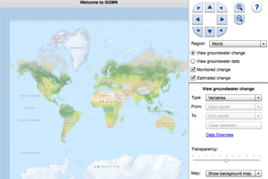
Screen capture of IGRAC’s GLobal Groundwater Monitoring Network |
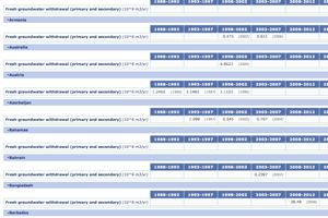
Using AQUASTAT to find data on groundwater withdrawal |
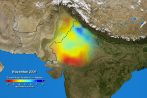
Groundwater level measurements give the best indication of the quantitative state of a groundwater system. However, installation and maintenance of observation wells is relatively expensive. Electromagnetic sensing is a practical method used for rapid groundwater detection and groundwater salinity assessments and can be executed for reasonable costs. Yet again, its applicability also depends on the geological conditions and measurements are only accurate to a certain depth. Innovative remote sensing technologies such as the NASA GRACE satellite mission are applied to obtain a complementary picture of groundwater storage changes. Proper interpretation of this satellite data requires significant use of proxy information and therefore information is only reliable over larger regions (200,000 km2) .
There is, however, still a lack of groundwater information at regional and global scale hampering assessment and informed water management. Groundwater monitoring networks are crucial for acquisition, collection and assessment of this vital information. Also combining data by harmonization and sharing of information among institutions allows for more complete and reliable groundwater assessments. This applies to groundwater data within a country, but also on the transboundary and global level. In addition, making data available to a broader public generates trust and could allow for more robust negotiations and responsible joint water management, if appropriately utilized.
Setting up information systems improves data management and facilitates groundwater assessments. Recognizing the need for a systematic collection of groundwater data, IGRAC (International Groundwater Resources Assessment Centre) began developing the Global Groundwater Monitoring Network (GGMN) in 2007. Since then IGRAC has been collecting data sets from publicly accessible sources and via participatory processes in the GGMN. Countries that already publish groundwater level data online are connected through automated data flows between these countries’ national databases and the GGMN.
There is an increasing effort to manage data on a global level; the United Nations Global Environment Monitoring System (GEMS) is dedicated to make (ground)water quality data available online, while FAO’s AQUASTAT focuses on providing global (ground)water and agriculture data. Global networks like Group of Earth observations (GEO) and WMO’s Global Climate Observing System (GCOS) and World Hydrological Cycle Observing System (WHYCOS), are initiatives to combine information from different hydrological cycle globally and thereby improve data availability and applicability. Nevertheless, the availability of groundwater data remains limited. Therefore, the expansion of groundwater monitoring and improved access to groundwater data worldwide are key measures to encounter the global water challenges.
i) Margat, J., & van der Gun, J. (2013). Groundwater Around the World. Leiden, Netherlands: CRC Press/Balkema
ii) World Water Assessment Programme (2009) The United Nations World Water Development Report 3: Water in a Changing World. Paris: UNESCO, and London: Earthscan.
iii) Siebert, S., Burke, J., Faures, J.-M., Frenken, K., Hoogeveen, J., Döll, P., & Portmann, F. T. (2010). Groundwater use for irrigation–a global inventory. Hydrology and Earth System Sciences Discussions, 7(3), 3977-4021.
Overview of online databases
- The atlas of Transboundary Aquifers: www.isarm.org/publications/324
- British Geological Survey (BGS): www.bgs.ac.uk/research/groundwater/datainfo/dataInformation.html
- International Groundwater Resources Assessment Centre: www.un-igrac.org
- U.S. Geological Survey (USGS): www.usgs.gov/aboutusgs/
- The Groundwater Information Network (GIN): http://gw-info.net/
- North Carolina Division of Water Resources: www.ncwater.org/data_and_modeling/Ground_Water_Databases/
- Ethiopian National Groundwater Database (ENGDA) www.mowr.gov.et/index.php?pagenum=2.2
- The Groundwater Bodies and Water Sources Database (DGV) of Sweden: www.sgu.se/sgu/eng/produkter-tjanster/databaser/hydro_databas_e.html
- Groundwater Monitoring Data Portal of Utah, USA: http://geology.utah.gov/databases/groundwater/projects.php
- Polish Disposable groundwater resources database: www.psh.gov.pl/en/phs_databases/disposable-groundwater-resources-database.html