By Femke van Woesik (MetaMeta), Jackie Kemboi (Justdiggit), and Samwel Jakinda (Justdiggit). The monitoring setup was developed and implemented by Tijmen Schults. The data extraction and analysis was done by Alex Ogelo
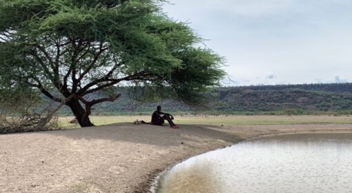
At the foot of the majestic Mt. Kilimanjaro in the south of Kenya lies the Amboseli National Park. This landscape is known for its impressive wildlife and beautiful nature. The area has a semi-arid climate with two variable rainy seasons, usually around November-December and March-April. Unfortunately, the effects of climate change are also felt here, resulting in more droughts, increased temperatures[1], and degenerated vegetation[2].
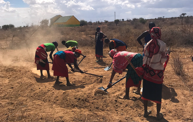
This degradation is why Justdiggit, as part of the Green Future Farming project, together with the local partner Amboseli Ecosystem Trust, aims to restore and regreen communal land in this area. One of these projects is the Meshenani Grass Seed Bank (GSB)[3]; a ten-hectare plot maintained and managed by Maasai women. The Meshenani GSB is located north of the ephemeral Amboseli Lake. Before this GSB is productive and grasses are fully grown, the land needs to be restored.
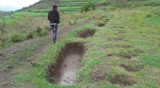
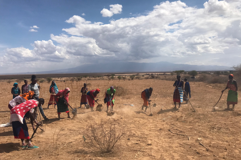
Restoration of the Meshenani GSB is done by a relatively simple technique: digging soil bunds that open the hard top layer of the soil and slow down and harvest rainwater that would otherwise have run downhill. This rainwater harvesting technique improves soil moisture levels, prevents soil erosion, and increases soil fertility. This way, the grasses sown in the area get a better chance to sprout, resulting in regreening and restoration of the plot.
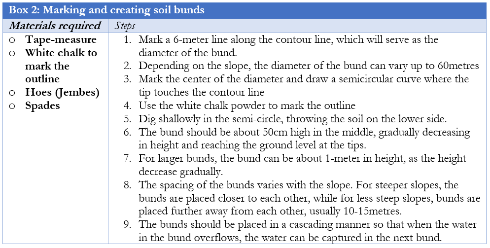
The digging of the soil bunds started in November 2021. When creating water harvesting structures, it is crucial to follow the contour lines of a landscape as this increases rainwater harvesting and soil moisture infiltration. Therefore, the contour lines were determined first with the simple method of a rope with a stick (Box 1). Second, the half-moon bunds were marked and drawn with tips on the contour lines (Box 2). Finally, the digging of the soil bunds started (Photo 3). Using an app called ‘Distance and Area measurement’[4] allowed for proper documentation of the structures. Multiple structures were built in series at a set interval to allow all water generated between lines to be retained by the following bund.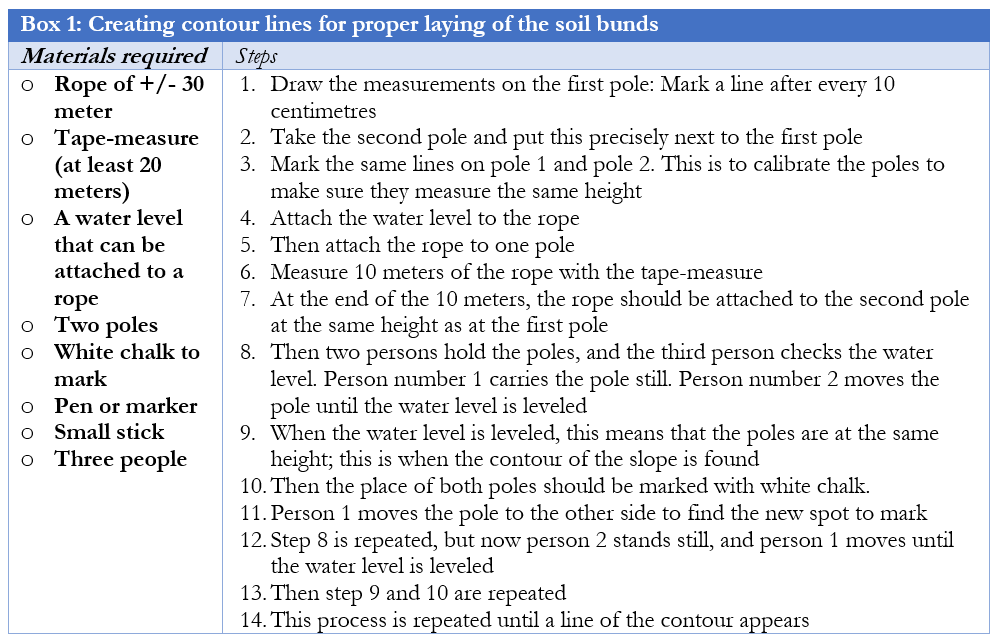
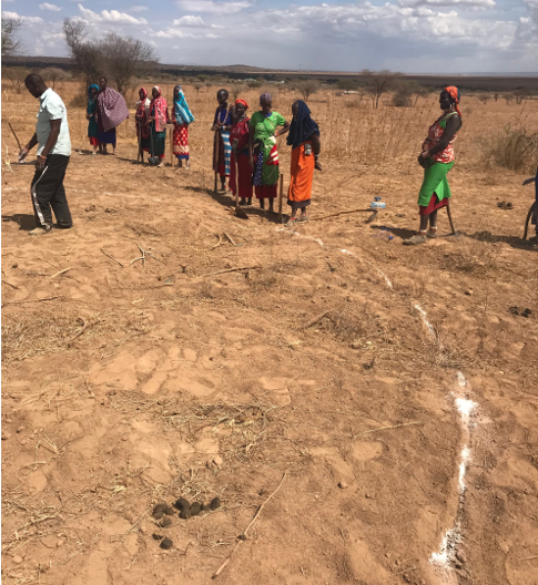
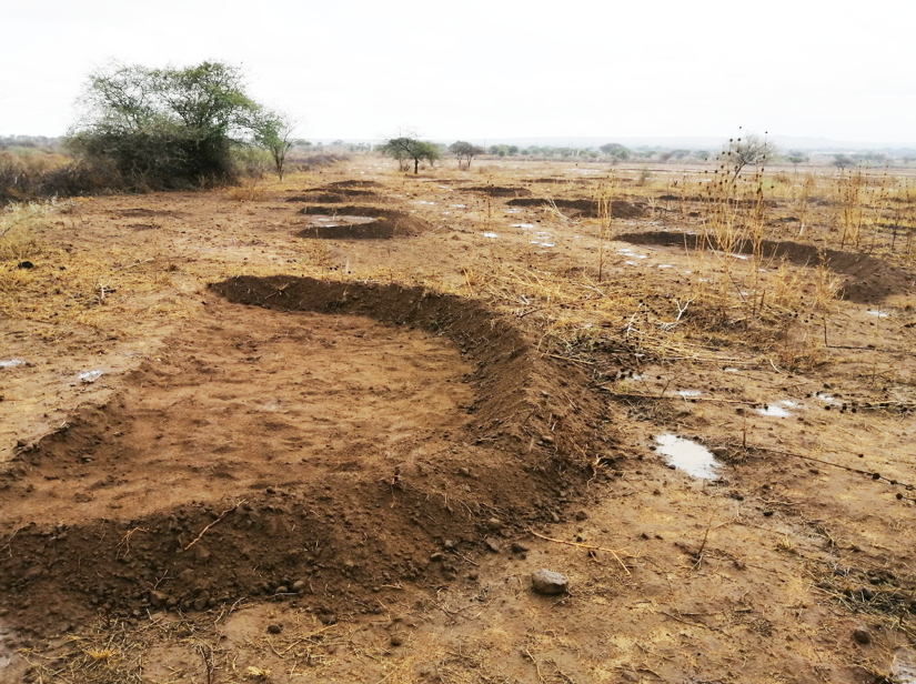
When it rains, the runoff water is now captured by the bunds and allows the water to seep into the soil, increasing soil moisture levels slowly (Photo 5). If the space behind the bunds fills up, the water can overflow to the lower tier of bunds or is discharged to a safe drainage waterway.
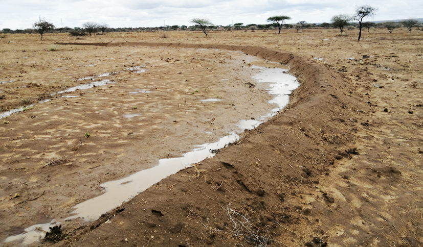
Another desired effect of the increased soil moisture levels is a decrease in soil temperatures and, consequently, air temperatures. This means that through the water harvesting capacity of bunds, these simple structures also have the power to buffer local temperatures and, as a result, improve the local climate.
To explain how soil moisture is related to buffering temperatures, we must look at the energy balance. The energy balance implies that all incoming energy from the sun must go somewhere within a system. Here, there are two options: solar energy is used for evapotranspiration or contributes to heating of the air and the soil. The first route is the latent heat flux, and the second is the sensible heat flux. How solar energy is diverted into these two energy fluxes highly depends on landscape characteristics. Soil moisture in a landscape enables evapotranspiration and, thus, the latent heat flux. This means that the energy from the sun will be used for this process instead of the heating processes. Changing the energy balance by enabling evapotranspiration will thus cool down the landscape as less energy is used for heating. See also this blog on how this can serve as a third way in dealing with climate change.
By increasing soil moisture levels and enabling evapotranspiration, soil bunds are thus able to regreen and cool down a landscape, restoring and improving its local climate. This is especially important in threatened landscapes such as the Meshenani plot, as since the 1960s, the daily temperatures in the area have increased yearly by 0.071 °C[1]. This highlights the need to increasethe area’s buffer against climate change and the vital work of the Maasai women in creating and maintaining the soil bunds.
To study these landscape interventions’ impact on the Meshenani plot’s local climate, a monitoring setup using TMS4 dataloggers[5] (Photo 6) was implemented in February 2022.
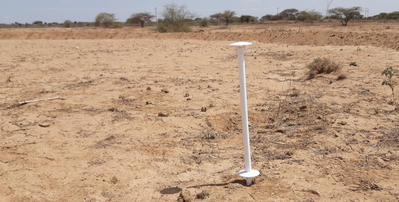
These sensors can collect data on soil moisture, soil temperature at a depth of -8 centimeters, soil surface temperature, and air temperature at a height of 45 centimeters. This allows for precise monitoring of the microclimatic changes. After six months of data collection, some preliminary results can be shared.
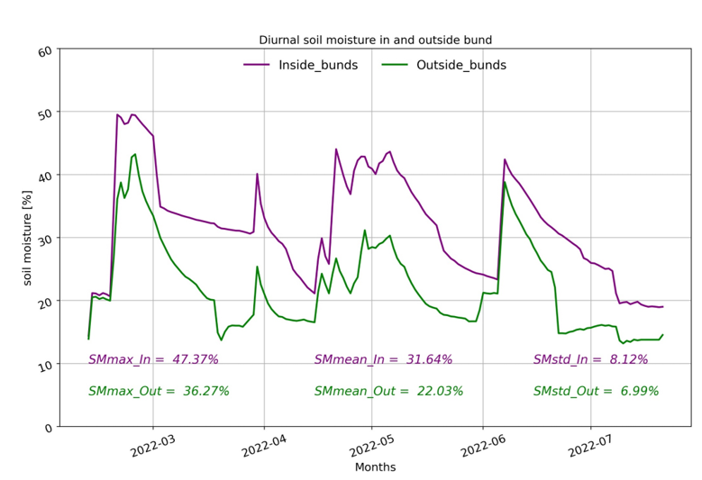
Figure 1 shows the daily changes in soil moisture over the entire period. From this graph, it can be concluded that the bunds generally have higher maximum and mean soil moisture values than those outside the bunds: Inside the bunds, the maximum soil moisture percentage measured was 47.4%; outside the bunds, this was 36.3%. The average soil moisture percentage inside the bunds was 31.6%, compared to 22% outside the bunds. What stands out in this graph is the lag in soil moisture content inside bunds compared to regions outside the bunds, and this is due to bunds being able to hold the water after a rainfall event for a longer time. Outside the bunds, the water levels drop faster again.
Figure 2 shows the daily changes in soil temperature. Day and night sinusoidal patterns are evident, with both regions exhibiting the same time lag. The mean temperature outside the bunds was 2.36ºC higher than inside the bunds. It is expected that this results from the increased soil moisture levels that enable evaporative cooling.
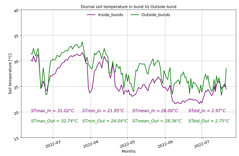
To better find trends in these data, more extended time series are needed to disentangle the seasonality and daily periodicity. However, even over this relatively short period, some interesting results were already found that advocate for these soil bunds’ capacity to improve the plot’s local climate.
This hopeful message tells us how it is possible to intentionally create better buffered local climates by proactive, well-considered, and measurable action. We can do this area by area, creating a mosaic of more robust local climates, all combined contributing to ‘making a new climate,’ as Judith Schwartz propositioned in the Reindeer Chronicles[6].
Are you interested in learning more ways to create favorable local climates? Stay tuned as MetaMeta and Practical Action Publishing publish the book ‘Managing the Local Climate’ in January 2023. This book shows how to positively affect the local climate and agroecological conditions with local interventions.

[1] Altmann, J., Alberts, S. C., Altmann, S. A., & Roy, S. B. (2002). Dramatic change in local climate patterns in the Amboseli basin, Kenya. African Journal of Ecology, 40(3), 248-251.
[2] Nyangena, J., Onywere, S., & Shisanya, C. (2020). Evaluating the relationship between drought and vegetation greenness in Chyulu-Amboseli Rangeland, Kenya. Journal of Applied Sciences and Environmental Management, 24(1), 65-71.
[3] https://justdiggit.org/work/kenya-amboseli-olgulului-ololarashi/
[4] https://play.google.com/store/apps/details?id=measureapp.measureapp&hl=nl&gl=KE
[5] Wild, J., Kopecký, M., Macek, M., Šanda, M., Jankovec, J., & Haase, T. (2019). Climate at ecologically relevant scales: A new temperature and soil moisture logger for long-term microclimate measurement. Agricultural and forest meteorology, 268, 40-47.
[6] Schwartz, J. D. (2020). The Reindeer Chronicles: And Other Inspiring Stories of Working with Nature to Heal the Earth. Chelsea Green Publishing.
