By Saroj Yakami (MetaMeta Research), Anurudh Kumar Shastri (PRADAN), Khusbu Bisen (PRADAN), Nitesh Kumar (PRADAN), Supriya Sharma (PRADAN), & Luwieke Bosma (MetaMeta Research).
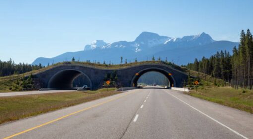
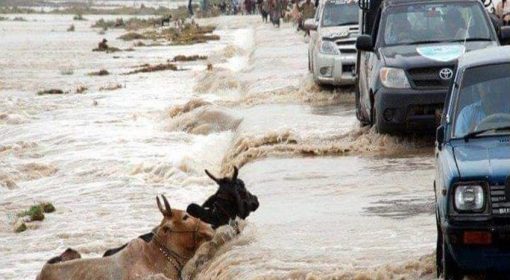
The basic idea of “roads for water” is to make roads instruments of beneficial water management and resilience. Roads make a major imprint on hydrology. They block and guide water, concentrate runoff, interfere with subsurface flows, and change flooding patterns. The impact of roads on landscapes and surface hydrology is often negative. Roads cause erosion and local flooding and trigger sedimentation. Road bodies are the main reason for drainage congestion and waterlogging.
Water is also considered the prime enemy of road infrastructure and the single greatest factor in road damage. A commonly used estimate is that for unpaved roads, the damage caused by water is around 80 percent (Chinowsky & Arndt, 2012) and for paved roads the proportion is 30 percent. There is a strong case for road-asset management to better manage water around roads and to see roads as an integral part of the watershed and landscape in which they are situated. The negative impact of roads on the surrounding landscape can be turned around and how roads can become instruments of beneficial water management. Roads provide an enormous opportunity to contribute to better water management and climate resilience. This will create the triple benefit of less road damage, less land degradation, and more beneficial use of water.
Many measures can be taken to manage water with roads. These are the main opportunities:
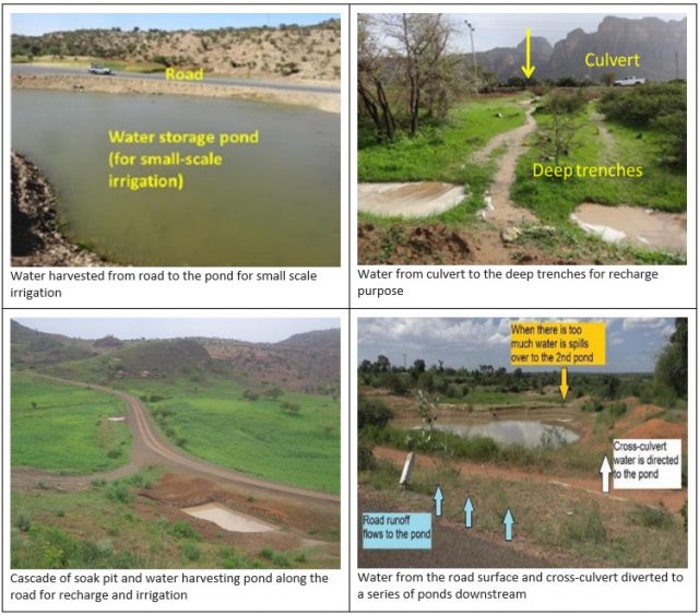
- In arid areas, roads can be used to harvest water (van Steenbergen et al. 2018). The water intercepted by road bodies can be guided to recharge areas or surface storages or can be applied directly on the land. With the enormous lengths of roads being built, roads present the main opportunity for water harvesting and water buffer management in semiarid areas (Salman et al. 2016).
- Roads can also be used to manage water catchments by controlling the speed of runoff, compartmentalizing and mitigating flood runoff, and influencing the sedimentation process in the catchments. The choices of where to place a road in a catchment and additional measures to include have a major impact on how a catchment is managed.
- Roads can improve pastoralist areas for instance by combining the concentrated run-off from roads with planting native grass species. Similarly, the road run-off can be used to rekindle the roots of useful tree species under farmer managed natural revegetation programs in very dry areas. Under such programs dormant tree shoots that come up after a sporadic watering event are systematically pruned and local tree stands in such harsh environments.
Roads and Water issues in Madhya Pradesh
Madhya Pradesh (MP) has an agrarian economy and a considerable proportion of the population is dependent on agriculture and forest resources for their livelihood.[1] But the state is largely rainfed where drought has been a frequent phenomena in a recent decade. In 2016, 46 out of 52 districts were declared as drought affected. Similarly, in 2019, 36 districts faced acute drought and water scarcity. Again, the spatial distribution of the rainfall remains highly skewed with some districts experiencing drought situations, while the rest of the state reels under heavy rainfall and floods.[2] Further the monsoon season lasts for 4 months (June-September) and the remaining period is hot and dry. This brings out two major issues, post-monsoon water availability is very low, and the uplands suffer from high erosion, resulting in runoff bringing siltation to the fertile lowlands. Both issues compromise the cultivation practices, thus livelihoods of people.
MP has an excellent roadways network which comprises national highways, state highways, district roads and village/rural roads. The 2019 data shows that MP has 365,045 km of roads[3] and the mean density of roadways is 22.14 km per 100 sq km in comparison to the countrywide mean of 37 km.[4] The different types of roads are regulated by different Authorities (see table below).
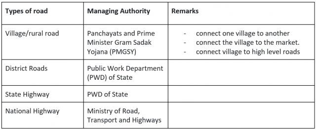
Panchayats at district and village level and PMGSY are responsible for the construction and maintenance of rural roads. PMGSY programme was initiated in 2000 AD with the objective of developing rural roads and connecting all villages having populations over 500 (and over 250 in hilly areas). Interesting fact of the rural road in MP was that most of the roads connecting one hamlet to another were concrete roads.
What is the work done on INRM and how could GR4W be integrated?
The Indian organization PRADAN (Professional Assistance for Development Action), has a long experience in developing Integrated Natural Resource Management (INRM) village plans, where it adopts the Ridge-to-Valley approach. This approach seeks to detain, divert, store and use available rainwater, starting from the ridge, the upper section of a catchment. The idea is to conserve every drop of water starting at the ridge and reduce to considerable extent both the surface run-off volume and the velocity of water. Under ridge-to-valley approach, soil and water conservation activities are taken up as area treatment and drainage line treatment (Swami 2021).
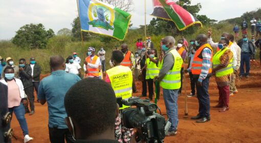
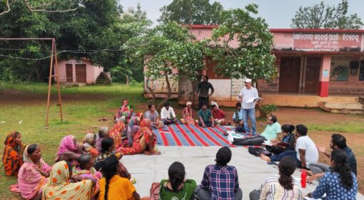
The Ridge-to-Valley approach has been the main driver for the INRM village planning process. In the NRM village planning workshop in MP, as part of the Green Transformation Pathways project[5] (September 2022), a wide range of measures was observed in the village. For instance, structural measures such as staggered trenches in upland, 30*40 model, field bunding, water harvesting structure, dug wells, check dams in streams, ponds etc. However, it was also observed that the focus had been on valley lands, while ridge or upland areas were not sufficiently addressed to ensure the complementarity of ridge and valley.
Further, we observed huge quantities of roads being constructed that connect villages and hamlets (most of them were paved roads) in the rural context of MP. These roads divide the drainage and divert and concentrate water to other directions, which could be used when properly managed but it creates havoc during monsoon time.
Looking at the context related to water and the huge quantity of roads in MP, there is a big scope for green roads for water (GR4W) to deal with drought, irrigation issues and siltation and to improve the livelihood of rural communities in MP. Below we selected a few structures that can especially be useful to increase water conservation in the upland/ridges and to connect roads for improved water management and harvesting.
Opportunities of GR4W in MP
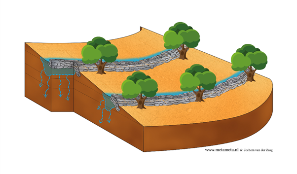
Contour bunds
Contour bunds are designed to collect enough water to recharge soils and provide water for plant growth during the dry season. They also protect soil from erosion and collect debris during peak rain events. The contour bund slows runoff, and intercept sediments and build up soil layers. Design criteria for determining the distance between bunds include slope gradient, rainfall intensities and infiltration rates. In the dry areas trees can be grown above the bund. In more humid areas plant trees on the downside to avoid risk of waterlogging.
– Stone- & stone-faced soil bunds (In 3-35% slope land)
– Soil bunds (In 3-15% slope land)
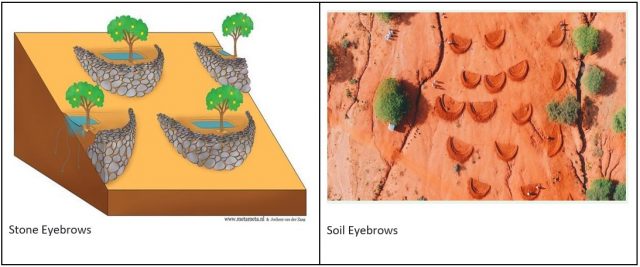
Eyebrows
Eyebrows are small, semicircular, stone-faced structures that open in the direction of the runoff. They can be built on steep slopes, usually with a maximum preferred slope of 50 percent. Eyebrow terraces can be complemented by stone strips or rock bunds, particularly on slopes that are relatively even and not too steep (less than 50 degrees). Eyebrows contain a water soaking pit and a planting pit as shown in the picture. Eyebrows function as micro-catchments for water harvesting.
Culvert water Spreader
Water from a culvert can be channelized into farmland away from roads and used for farming, groundwater recharge by diverting it to ponds, and improving soil moisture. In steep areas a V-shaped spreader ensures water is guided gently in two directions and no gullies are developed.

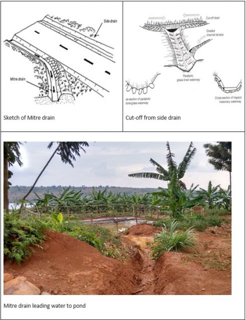
Mitre drain/cut-off from side drain
The Mitre drains lead away the water from the side ditches to lower areas. In principle, the more mitre drains the better. Figure below shows water from Mitre drain leads to a pond with a silt trap.
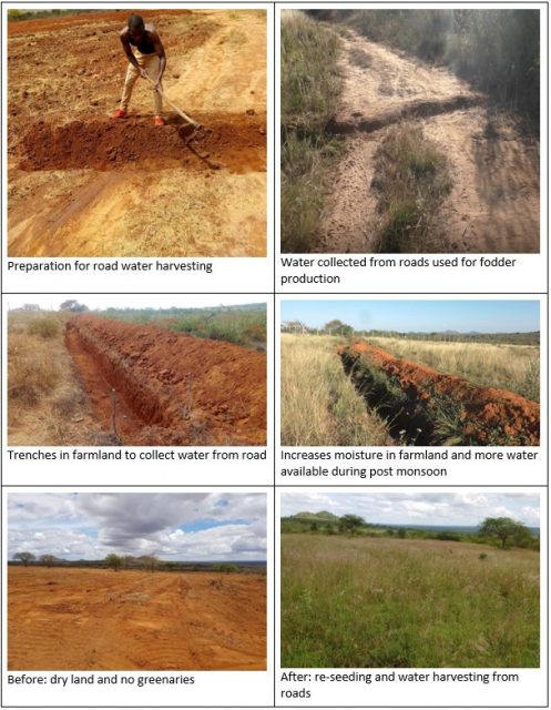
Pasture Production from water harvested from road
A cascade of low-cost and small-scale water harvesting measures capturing runoff from roads, and linking it specifically to common lands (common land consists of 25% of total geographic area in India), could prove to be a good fodder-baskets for livestocks and improve the livelihood of communities linked to livestock.
Main lessons and next steps
Upland area in INRM village planning
One of the difficulties implementing Ridge to Valley approach/treatment in INRM village planning is the upland areas. In MP, a large chunk of upland areas are under the Forest department. Forest department has its own rules and regulations to treat upland areas. At present, INRM village planning is done by PRADAN together with communities only and in the presence of MGNREGA, a panchayat. This has limited the planning process in the downstream area or the low land areas within the village boundary only. Forest department is the main stakeholder for INRM village planning process in MP due to following reasons
- major chunk of upland area of the village comes under forest department
- Sediments and debris from forest area are big issue for communities
- Water from the upland areas, if managed properly, could be good resources for agriculture during post monsoon period
- Non Timber Forest Products (NTFP) from the forest is a good source of income and livelihoods for the communities.
At this time, there is no consultation with Forest department or Forest department is not considered a stakeholder while performing INRM village planning. Collaboration with the Forest department is essential to complete the Ridge to valley approach/treatment or planning process in upland areas for the INRM village planning process.
Enhanced learning and piloting
It came out from the online sessions and INRM village planning workshop that GR4W concept and measures require more in-depth learning. In order to integrate GR4W into the larger INRM implementation in the villages specific knowledge on: i) the range of GR4W options focusing on the conveyance of road runoff water for retention and recharge, ii) governance approach with new group of stakeholders, and iii) integration into INRM village planning, commons and fodder production. We therefore propose to work on developing a series of training sessions on GR4W coupled with piloting in selected villages. Such learning by doing would greatly improve co-creation of knowledge among multiple stakeholders and can improve the practicality for on-the-ground implementation.
REFERENCES
Salman, M., L. Bunclark, M. AbuKhalaf, C. Borgia, L. Guarnieri, O. Hoffmann, F. Sambalino, F. V. van Steenbergen, and F. Lebdi. 2016. Strengthening Agricultural Water Efficiency and Productivity on the African and Global Level: Status, Performance and Scope Assessment of Water Harvesting in Uganda, Burkina Faso and Morocco. Rome: FAO.
Swami, S. 2021. Ridge-to-Valley Treatment of Hilly Terrains for Efficient Soil and Water Conservation. Soil and Water Conservation Today. Vol 16 No. 3. (https://www.researchgate.net/publication/355900185_Ridge-to-Valley_Treatment_of_Hilly_Terrains_for_Efficient_Soil_and_Water_Conservation)
van Steenbergen, F., K. Woldearegay, M. Agujetas Perez, K. Manjur, and M. A. Al-Abyadh. 2018. Roads: Instruments for Rainwater Harvesting, Food Security and Climate Resilience in Arid and Semiarid Areas. In Rainwater-Smart Agriculture in Arid and Semi-Arid Areas, edited by Walter Leal Filho and Josep de Trincheria Gomez. Cham, Switzerland: Springer International Publishing.
[1] https://mpforest.gov.in/img/files/GIM_Revised_Plan_finaly_18_07_16.pdf
[2] https://www.indiawaterportal.org/articles/madhya-pradeshs-recurring-droughts-measuring-responding-and-reducing-vulnerabilities
[3] The Green Transformation Pathways (GTP) project in the Indian states of Madhya Pradesh and Jharkhand aims to create a vibrant circular rural economy based on an extensive exchange of valuable products and services, supported by strong institutions and value chains. This is done through fostering sustainable management of natural resources and regenerative agriculture practices that add to the quality of life.
[4] https://www.mapsofindia.com/maps/madhyapradesh/madhyapradeshroads.htm
[5] https://thewaterchannel.tv/dossiers/uncategorized/green-transformation/
Supported by: