By Hasna Heena Mahmud, Aysha Akter Smrity (Uttaran), supported by Mst Jannatul Naim
This blog is part of a dossier on locally-led adaptation, featuring insights and lessons from the Reversing the Flow (RtF) program. RtF empowers communities in Bangladesh, Burkina Faso, Ethiopia, Kenya, and Sudan to build climate resilience through direct funding and a community-driven, landscape approach.

Life in a changing coastal landscape
In this low-lying coastal belt of southwest Bangladesh, people live with slow disasters that never fully end. Riverbank erosion along rivers like the Kapatakkho has eaten away at ancestral homesteads, forcing families to move again and again onto newly formed khas land that is exposed and insecure. Twice a day, the tides push saline water deep into the landscape, turning soil salty, damaging houses, and making it difficult to grow crops or keep freshwater fish. At the same time, many canals have become silted or blocked, trapping monsoon rain so that villages remain waterlogged for months, with fields, homes and roads under water, children cut off from school, and skin and water-related diseases on the rise.
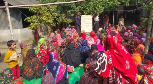
In the Reversing the Flow (RtF) programme, and with Uttaran as the local hub, communities in Chakla, Bagerbil and Jeyala decided not to accept this situation as their fate or wait for outside projects to rescue them. Instead, they came together to analyse how their rivers, canals and embankments really work, discussed the trade-offs between different water uses, and agreed on priorities that matched their own needs. Using RtF re-granting funds as a starting point, they organised collective action and opened dialogue with government institutions to repair weak embankments, clear blocked drainage routes and negotiate new investments. Step by step, they are working to make water management in their landscapes fairer, more inclusive and more sustainable, on their own terms.
Chakla Community: Rebuilding an embankment, step by step
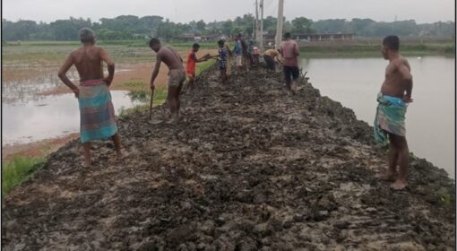
For years, Chakla’s people watched the Kapatakkho river eat their homesteads and cropland, pushing them onto fragile, saline khas land. Shrimp farming became one of the few options, but it locked the landscape into salt, making agriculture and freshwater fish almost impossible. The community chose a different path. Through village discussions, they agreed that the first priority was to stop tidal saline water from entering their land. They organised a fully community-led initiative to repair 3.5 kilometres of embankment, investing about BDT 2 million of their own and local resources, and ensuring equal wages for women and men. Now saline water intrusion is much lower, and Chakla is waiting patiently for soil to recover before moving into freshwater aquaculture and crops.
People know it may take at least three years of rain to wash out the salt, so they are monitoring weak points in the embankment and planning the next phase together. Chakla community is leading how locally led adaptation can be slow but strategic: first protect the land, then restore livelihoods, without rushing into risky investments.
Bagerbil Community: Advocacy that unlocked other priorities

Bagerbil faced another form of water crisis. A blocked canal meant that even normal monsoon rains turned into long-term waterlogging, with fields, roads, and courtyards under water for months.
Agriculture and aquaculture declined, mobility was restricted, and children often could not reach school. Instead of only digging canals with project money, the community started to think about how to change the system. They used RtF spaces and meetings to analyse why drainage was failing and which institutions should be responsible.
Community representatives then engaged the Local Government Engineering Department (LGED) and other local actors to demand permanent structures for drainage. Through repeated dialogue, they secured agreement for five box culverts: LGED would finance and build the largest one, while the community would construct the remaining four using their own labour and project regranting fund support.
This choice freed around BDT 400,000 in RtF project funds that can now support other priorities in the landscape, such as livelihood activities or further water management work. For the Bagerbil community, the key shift was from project-delivered works to community-led advocacy that brings the government into its proper role.
Jeyala community: From conflict to compromise in water management

Jeyala community also lives with chronic waterlogging. Community members traced the problem back to abandoned tunnels and a broken connection to the West Shalta River that once allowed excess water to drain out. Through meetings and mapping, they agreed to push for a new culvert to reopen this old drainage route. They proposed a partnership: the community would mobilise funds, while LGED(Local Government and Engineering Department) would design and supervise construction. LGED authorities accepted, and work began.
However, farmers in neighboring Dumuria feared that the restored flow would flood their fields.
They protested, halted construction, and appealed to higher authorities. After several rounds of dialogue, site visits, and review at Union, Upazila, District and even Member of Parliament level, the culvert was finally stopped.
The people of Jeyala could have kept fighting, as the land in question was legally Khas (government-owned, unleased land that has vested in the state by operation of law). But they recognised that many poor farmers were now using that land through leases from powerful landholders. They decided not to push a solution that might harm another vulnerable group. Instead, they turned back to their own canal network. By cleaning and re-excavating blocked sections, they re-established an alternative drainage path through Kazir Ghat Canal to Ghater Khal. This solution may not be perfect, but it reduces waterlogging while avoiding conflict with neighbours.
What these stories mean for locally led adaptation
Across the three landscapes, with the Reversing the Flow programme, the communities are not just implementing isolated activities; they are practising a deliberate, reflective and negotiated way of working. They start by jointly analysing the root causes of their water problems, draw on their own histories and knowledge of rivers and canals, and then decide together which structural constraints need to shift first, such as embankment breaches, blocked canals or missing culverts.
Their approach is grounded in collective leadership and locally led: people pool their own labour and resources, and use their own funds as leverage to engage state actors rather than replace them.
They treat government agencies as partners to be persuaded, not passive funders, and are willing to adapt or even abandon technically sound plans when these create social conflict or harm neighbouring communities. In this way, the three landscapes practice a slow, strategic form of locally led adaptation that focuses as much on power, relationships and justice as on physical infrastructure.