By Md. Saif Uddin, Lutfor Rahman and Frank van Steenbergen
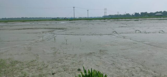
It is river but without water. Instead of water there is silt, silt from bank to bank. The Sholmari River is one of the many tidal rivers in the Bangladesh South West coastal belt. In all these rivers there is a very fine balance between water coming in with the tides from the sea with sediments and the sediments are pushed downwards with upstream flow which has been reduced ever since India diverted more water upstream with the construction of Farakka Barrage in 1975.
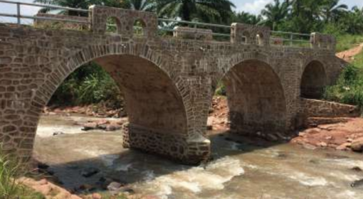
The Sholmari river is now dead, besides less upstream flow, the other culprit is the Batiaghata bridge that restricted and choked the river. To save on costs, the bridge was made more narrow then the river width and bridge span length was kept small which increase the number of piers. Large number of piers in the river change the river hydro-morphodynamic condition which increases the sedimentation in the river. In other words the construction of the bridge set in motion a chain reaction that totally destroyed the river. With the changing morphology also the inland reach of the tides was affecting, further disturbing the river.
The end result is a dead river full of sediment – blocking the removal of water from the adjacent land, where cultivation becomes impossible and habitation difficult. This is the high tragedy. As the land cannot drain into the blocked river, water logging becomes widespread and farming systems and residential areas are destroyed. Including Beel Dakatia, the area of the 23 small and major beels that are affected approximately 1,500 hectares. An estimated 2,500,000 crores worth of agricultural and fishery products are produced annually in the aforementioned region. These areas are at risk of experiencing significant inundation due to the siltation in the Sholmari River. Several thousand already poor people may have to pick up their belongings and go nowhere.
The Sholmari river is not the only river killed by bridges, there are more examples in almost all rivers in the Southwest Region.Over the last 40 to 50 years, infilled channels have added around 90 km2 of new land, or about 2 km2 every year. The loss of tidal waterways accounts for a 60% reduction in total channel length over the region’s 3000 km2 of poldered terrain, or roughly two-thirds of the region’s navigable waterways over the last 40 years .It all speaks for making a strong connection between building roads and bridges and managing water and silt, and where possible go for mutual beneficial effects. It speaks for counting in local hydrology whilst developing infrastructure. It speaks for r than not working in isolation but in combining perspectives and finding synergy.
![]()
![]()