Mehmet Gorus, Shubham Jain and Meghna Mukherjee
Agricultural landscapes today are under immense pressure from intensive farming practices, resulting in widespread biodiversity loss and soil degradation. To address these challenges, researchers and development organizations are increasingly turning to nature‑based solutions such as hedgerows. But having a good idea is only half the battle—the real challenge lies in figuring out exactly how and where to implement it.
While exploring the potential of planting hedgerows, or “green corridors,” to protect soils in the villages of Dudhera Ryt. and Pondi Ryt. in the Dindori District of Madhya Pradesh, India, a significant practical challenge quickly emerged: the where. Smallholder farmers in these regions are already facing increasing water scarcity and declining farm productivity. They simply cannot afford to lose valuable agricultural land to poorly placed interventions.
This reality sparked the core question that guided Mehmet Gorus’s internship research at MetaMeta:
Where exactly should we plan these green corridors so that productive land isn’t wasted, and the community gains the maximum benefit?
Traditional planning and field‑based assessment methods are often costly, time‑consuming, and limited in scale. What was missing were precise, data‑backed answers—without relying solely on extensive field surveys. This dilemma became the motivation to tackle a real‑world problem during my internship.
Taking a Bird’s‑Eye View
Rather than conducting manual field assessments, I adopted a landscape‑level approach using Geographic Information Systems (GIS). Think of GIS as a smart digital map that allows you to layer different types of geographic information—such as satellite imagery and elevation models—to reveal environmental patterns that are otherwise difficult to detect.
Because hedgerows are narrow, linear features embedded within vast agricultural landscapes, a highly detailed spatial perspective was essential to identify the most suitable locations. The goal was not simply to find unused land, but to pinpoint the most strategic sites—where a relatively small intervention could deliver the greatest ecological and agricultural benefits.
Here is the story of how we found those spots:
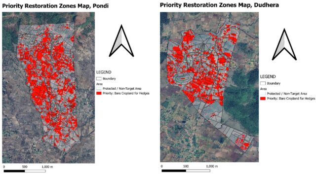
- Spotting the Dry Zones: Satellite imagery from 2016 and 2025 is compared to identify long-term vegetation trends. This helps to identify “Aridity Hotspots”, specific zones where the green cover has significantly decreased over the last decade.

- Finding the Empty Fields: Next, Data is filtered to isolate ‘Bare Cropland’, agricultural plots that are completely devoid of vegetation during the dry season. These fields are highly susceptible to wind erosion and moisture loss, making them perfect candidates for boundary hedges that do not displace productive farming land.
- Following the Water: Finally, Digital elevation models are utilized to map the hydrological movement across the landscape. Firstly, we made runoff control & critical interception points map to find out the places where water discharge is in peak, and where water accumulated more.
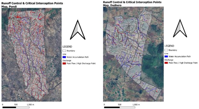
The convergence of these data layers allows for the precise identification of ‘Critical Interception Points’. They are where the natural water paths (blue lines) and high-energy ‘danger points’ (red dots) cross the existing farm boundaries.
Seeing the Plan in Action
To give you a clearer picture of what this looks like in practice, take a look at the Priority Intervention Plots maps we generated for the villages of Dudhera and Pondi.
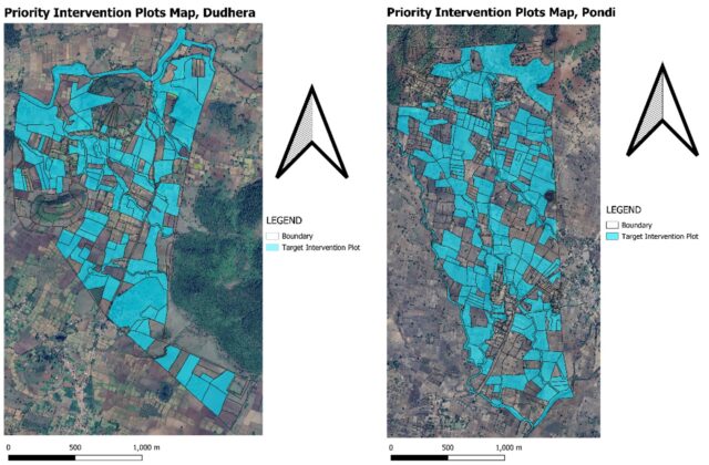
In these maps, the areas highlighted in bright blue are not just random fields. They represent the exact land parcels where our three critical factors—water flow paths, peak water discharge, and existing plot boundaries—all converge
From Maps to Reality
The digital map is only the beginning. Turning mapped insights into successful, on the ground interventions requires several critical next steps.
- Walking the Land (Ground Truthing & Tenure): A map is only as good as the reality it represents. Proposed hedge lines must be validated against local land records to ensure tenure security. Equally important is physically visiting the sites to confirm that the topographical thresholds and conditions identified in the model hold true on the ground.
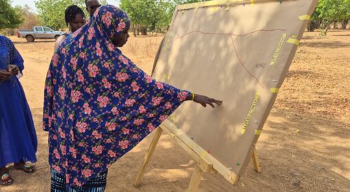
- Partnering with Farmers (Community Engagement): The long term survival of these hedgerows ultimately depends on the willingness and capacity of local landholders to maintain them. Meaningful engagement with farmers ensures that the interventions are not only technically sound but also socially accepted and locally owned.
- Testing the Dry Season (Temporal Data Enhancements): The current analysis relied on satellite imagery captured just after the monsoon (November–December), when vegetation is at its healthiest. Future research should incorporate pre monsoon imagery to assess how these vegetative barriers perform during the most climatically challenging, dry months of the year.
Together, these steps bridge the gap between spatial analysis and real world impact. By combining data driven planning with field validation and community collaboration, green corridors can move from lines on a map to resilient, living infrastructures—supporting both ecological health and farmer livelihoods over the long term.