Frank van Steenbergen and Adel al-Weshali
March 10, 2021
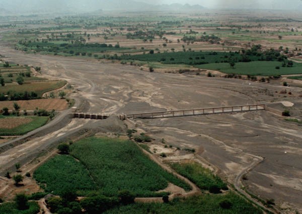
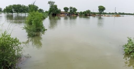
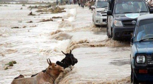
Here is the Wadi Zabid spate irrigation system in the Tihama in Yemen: a dry river coming out of an arid mountain landscape, extending 50 kilometers before it reaches the sea. When it rains in the catchment the river occasionally carries a flood flow, lasting from a few hours to a few days. The turbulent floods come with high silt loads. They are diverted by earthen bunds pushed up in the dry river beds. These earthen bunds guide the flood water to the land where it is diverted to the fields through a network of wide earthen canals. This is the essence of spate irrigation, a form of water management in arid countries that uses short term floods to serve agricultural land, pasture, or groundwater recharge. Spate irrigation has a history of millennia in Yemen, including feeding the lands of the fabled Queen of Sheba.
Zabid is one of the Yemen’s oldest towns. It is also where Sheikh Bin Ibraham Al-Jabarty lived, a famous scholar who died in 1472. What Sheikh Al-Jabarty did nearly 600 years ago – after hearing all experts and in line with customs of the time – was to modify the common alfa’ala falah ‘upstream first’ rule. Instead he introduced time zones – restricting the time upstream land owners could use the water. The upstream areas measuring some 4300 ha were allowed to divert all water from 6 October to 20 July. This entitled them to the base flow in the river and many of the main floods – as the flood season is at its peak from May to September. After 20 July all water had to passed on to the middle command area, measuring 9200 ha, that would get floods up to 31 August – which is the peak flood season. From 1 September up to 5 October the lower command area (measuring 1300 ha) was to be served, but this is also a period when no flood may come. The command areas were also well defined and no land could be irrigated twice within a 14 day period.
The rules favored the upstream areas as they were entitled to the base flow of the river, and could also divert flood water in the rainy season when most floods arrive. The same applies for the middle area. The lower riparian, however, were dependent on the floods.
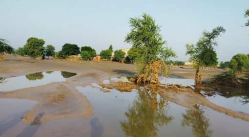
However, there was a respite. Soil bunds did not stand up to the larger floods. They would break on the impact of the floods or fail because they were not well compacted or undermined by rodents. The floods would then move downstream, even when they would occur in the time slot of the upper riparian. These runaway floods were never lost. They would reach the downstream areas where they would water the land and recharge the drinking water wells.
All this changed from 1970 to 1979, when permanent weirs were constructed replacing the traditional soil structures. This had two effects. First, the permanent structures eliminated the possibility of a run-away floods in the main season. A second change was that the new structures were impermeable and anchored on the bedrock in the wadi. As such they blocked the subsurface flow in the wadi – further accelerating the collapse of the drinking water wells in the downstream area. As a result the downstream area gradually started to dry up. The impact was most dramatic in the coastal villages around Al-Majehlis where soil moisture gradually disappeared and could no longer sustain the date groves in the area. Over time this area was overtaken by sand dunes. The inequity was further amplified as in the upstream area rich farmers diverted more and more water even beyond their time slot, trying to develop new land.
Then in 2019 – in the middle of period of conflicts and war in Yemen – something remarkable happened. The system of water allocation changed so as to give way to an arrangement that ensured much more equity. Rather than following the nearly six hundred year old Al Jabarty rule on time slots, that increasingly deprived the downstream areas, a new rule was made. Under this rule after land was irrigated with a flood once– it could not be irrigated again in a next flood burst– and the next flood had to go to the next area and so on. Also the depth of water put on the land was limited to 40 centimeter and authorized command area expansions were cut off. This new rule favored the downstream areas and water was passed on to the entire command area including the tail. It spread farm production over a larger area and helped restore the water levels in the wells.
There were a number of important drivers for this change. The main instrument was the High Council on Agriculture and Fishery that took the lead in discussing the new arrangement, with the body having seen the same transition to new rules happening in another wadi in the Tihama, Wadi Mawr. In Wadi Mawr it was facilitated by a civil society organization promoting local water management, in conjunction with the High Council. In Wadi Zabid extensive discussions were held by High Council with local leaders. A turning point was when downstream people were invited to visit the upstream areas and witness the way water was used there and discuss how this affected them. In discussion with the leaders, the old rules were changed to a far more egalitarian arrangement that caused both the entire command area to be irrigated in 2019 and 2020, for the first time in thirty years. The water distribution rule is enforced by the Tihama Development Authority that is responsible for maintenance and oversees the water distribution. It is remarkable that this change happened during a period of severe crisis. Despite the war, new windows of opportunity could be opened up through new leadership and cooperation around land and water. The same change in water allocation that took effect in Wadi Zabid and Wadi Mowr is now also introduced by the High Council in other wadis in the Tihama.
Prepared in support of the development of Voluntary Guidelines for Sustainable Water Allocation in Agriculture by FAO, ESCWA and AOAD for the League of Arab States.