Frank van Steenbergen, Popi Michelogiannaki and Mohammed Umar Karim
Drainage: roads disrupt
Floods are not only about excessive rainfall: they are also about drainage. The recent floods in Pakistan were aggravated and prolonged as the natural drainage system was much distorted due to (1) impediments in particular bridges and farmland in the flood plains of the main Indus River (2) water logging in large parts of the agricultural land making it difficult to absorb run-off and (3) the erratic rerouting of storm water by uncompleted drainage systems in Sindh, i.e., Right Bank Outfall Drain (RBOD) and Left Bank Outfall Drain (LBOD). Yet a fourth very important factor is the distortion of the natural drainage patterns through the construction of irrigation and drainage canals, housing estates, railways track and – very importantly – roads.
The larger picture is that in many cases such infrastructure has blocked the natural drainage lines. Hence during heavy rain, run-off is concentrated and guided in unpredictable directions. The flood protection bunds along the main irrigation canal in Balochistan, the Pat Feeder (first build in 1967) for instance has no cross drainage to speak-off over a length of 187 kilometres. Because of the Pat Feeder and Khyrther flood protection embankments, floods in the Kachhi Plain are bundled and all end up in the narrow section of the Dhorei Chuki in Sindh. Another example is the construction of the LBOD drainage network, where the drains – including the Spinal Drain – meant to remove excess agricultural water among in some cases blocked the removal of stormwater, in addition to roads with under-dimensioned culverts and bridges or altogether missing cross-drainage. All this was the major aggravator of the floods of 2011 and 2012 according to ‘Regional Master Plan for The Left Bank of Indus, Delta and Coastal Zone’ (2013). The same master plan proposed a 400 M USD investment to restore the natural drains (dhoras) in Sindh – to better deal with floods and reduce the extensive water logging in some areas.
In other words, the natural drainage in the flat areas of Balochistan and Sindh is replaced by a large, distorted drainage network, with floods flows evacuated in an uncontrolled manner. With the passage of time and execution of development works the natural waterways which used to provide storm water drainage, have been completely blocked by inadequate or no crossing structures for roads, railways, built environment and irrigation canals. Natural water pathways have been filled up and are being utilized for crop cultivation and community housing. In restoring flood damage and rebuilding roads, the main obstructions need to be unblocked.
![]()
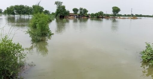
Image 1: Flash floods coming from Baluchistan to Sindh province, in Sep 2022
Getting the cross drainage right
As mentioned, ideally cross-drainage structures should as much as possible align with the natural drainage paths: water from the upper catchment to pass underneath roads and connect these watercourses directly to the downstream portion of the catchment. Despite the importance, in the real world the number of cross-drainage structures is often minimized for cost reasons, resulting in roads guiding and concentrating naturally distributed runoff water to other locations. The changed rainfall patterns combined with more frequent monsoon outbursts makes cross-drainage structures more urgent.
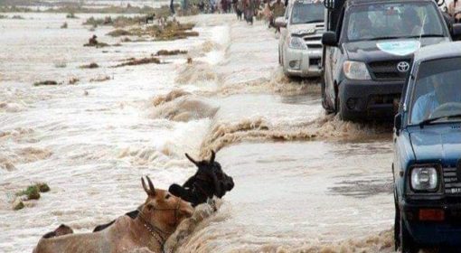
The lack of and inappropriate road cross drainage in Pakistan was very visible in the recent floods. Due to the incapability to drain the flow of floodwater in Sindh province, cutting roads in many areas of Sindh was the only resort to allow floodwater to pass into the Indus River. The two main avenues of Pakistan, the Indus Highway (N-55) and National Highway (N-5) built on elevated embankments, were breached in different parts to protect cities. This not only caused damage to the surrounding areas, but also impaired the most vital connectivity in the country.
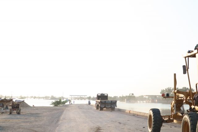
Image 2: Indus Highway in Sindh, after being cut off to connect floodwater from Manchar Lake to the Indus River. Photo taken by: Aamir Ali Panhwar
Cross drainage is also an important element in local roads, many of which went underwater in the floods. District roads designed without paying attention to cross drainage if not entirely flooded were affected by erosion, slumping and subsidence. The interrupted streams and torrents damage the road surface by their erosive force and create extensive wet road sections that are easily destroyed by traffic impact.
One important observation during floods 2022 was the collapse of bridges on natural waterways/hill torrents. The design of highway bridges, specifically on hill torrents, requires consideration of hydraulic pressures corresponding to structural strength, as well as the flood protection works to protect its foundation piling. One problem identified is unregulated sand mining up and down stream of bridges, which directly influences the high level and high quantity of rain waters. The flow direction is changed, which erodes the vulnerable parts of structure, as shown for instance in before and after images of collapsed Hub River Bridge (image 3 and 4).
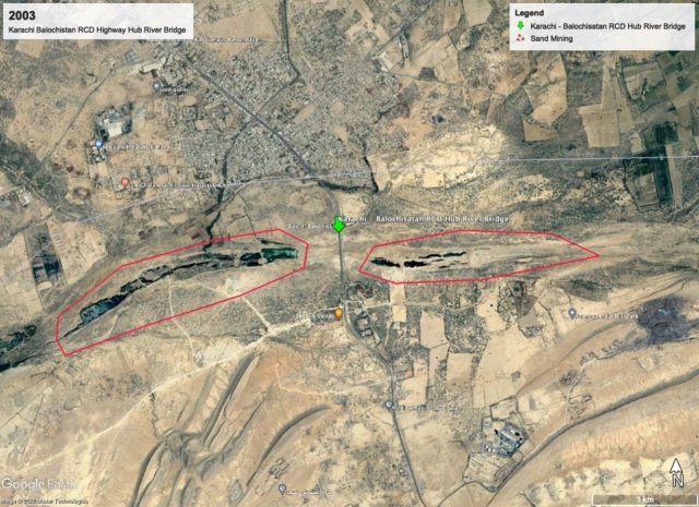
Image 3: (2003) limited sand mining and stable riverbed in Hub River Bridge, Balochistan
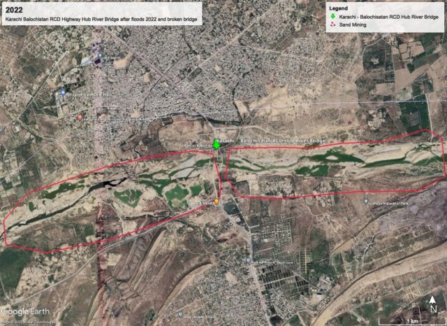
Image 4: (2022) Extensive sand mining and braiding riverbed, Hub River bridge collapsed, Balochistan
Building back better: roads to compartmentalize and recharge
The Pakistan Disaster Management Authorities figures show that 33 percent (8.463 kilometres) of roads in Sindh are damaged in the floods of 2022. There is large need to restore the road network. It figures as a major item in Post Disaster Needs Assessment. There is a huge need not only for repairs but for building back better as well. It is argued to replace the distorted drainage network with a controlled network – which may retain floods and where possible make beneficial use of the floods. In building back the road network there are three important considerations: (1) to unblock the natural drainage network, starting with the most critical obstructions; (2) to explore the compartmentalisation of the flat landscape with the road network, in order to retain some of the floods in a controlled manner and (3) to design the road stormwater system in such a way that flood water could be used to recharge groundwater or supply surface storage.
This requires a good understanding of the inundation patterns as they have occurred in recent floods and are likely to happen in future heavy rainfall events. This will give pointers as to where floods accumulated and created havoc and where they should have mitigated by restoring drainage paths. Sometimes this may partly pay for itself giving permission to remove sand or silt, rather than having a contractor do this as a job. The inundation models also will highlight the most vulnerable (low-lying) areas that are likely to suffer from immersion for extensive periods. Second is to assess blocked culverts, check inadequate sized culverts and bridges for quick evacuation of storm water to Indus River from productive lands and nearby cities. An adequate number of culverts on drainage lines along a road body is an important consideration when designing for beneficial water management. The number and location of these structures determine the opportunities to collect water, retain moisture, and control erosion and sedimentation. Here we can go a step further. In a flood situation it may also be useful not to evacuate water as soon as possible, as the floods can become uncontrollable and destructive. In flat areas, such as the lower part of Pakistan, it is useful to explore also how floods can be attenuated and slowed down. This is done by blocking drainage and manipulating the speed of run-off. The system divides the landscape into compartments, with run-off managed in a system of interlinked compartments. This may mean controlled cross drainage, including the use of flood gates. The final consideration is also to see where the floods are best retained and can be put to good use, for example, in groundwater recharge. In this way, with the proper rebuilding of the road networks floods can become an asset. In this case, the redesign of the roads (and other infrastructure) in the relatively empty areas up from the densely used Indus irrigation systems is important. What is required is to take steps from the current chaotic pattern to reach a controlled stormwater drainage network.