by Frank van Steenbergen and Mohammed Ehsan Leghari
Flood resilience and the management of land and water resources
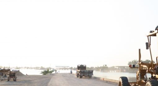
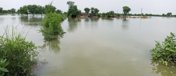
The floods of 2022 in Pakistan were episodic in their devastation, covering one-third of the country. They were caused by unusually high rainfall, but in an equal measure, they were the result of a distorted land management system that was unable to evacuate the high volumes of water.
The flood – following on flood events in 2010, 2011, 2012, 2016, and 2020 – triggered a highly needed discussion – how do we make sure that another undue water event does not create the same deep effect and lasting impact? What changes are required? Do we need to change the system? Where do conventional flood embankments fit in? They are not always liked, not always well-constructed, and sometimes unnecessary. Instead, what is the alternative approach to avoiding floods that build up vehemently and become devastating? And, can we turn the floods into an asset rather than a force of destruction? In summary, how do we create flood resilience in the land and water management system?
This is a major transition. The concept of resilience has a pendant in every field: raised flood-proof houses, better medical systems, rethinking of the transport network, management of essential stocks, less vulnerable farm and livestock systems, and more resilient education facilities. The thinking in general is that these are not separate investments, but add-ins and adjustments to make the system work better in general, as well as perform under the duress that comes with floods or other disasters. Many of the improvements would be useful, even without contributing to better disaster preparedness.
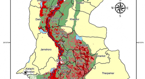
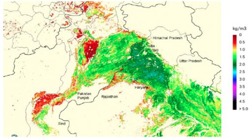
Here, we concentrate on flood resilience and spatial planning. In an earlier White Paper[1], issued in January 2023, the stronger combination of flood management with spatial planning was advocated. Several examples were highlighted where the impact of the 2022 floods was amplified because of the lay of the land and the infrastructure built on it, interfering in generally negative and only sometimes positive ways. In general, spatial planning in relation to flood management has not been given much consideration. This has given rise to distorted storm water removal, amplifying flooding, taking it to unexpected places, and prolonging inundation. The White Paper argued for an overhaul of land and water management, so that in the future floods would not accumulate, but would be mitigated and even be put to beneficial use. Below is a summary diagnosis of what hampers the land and water management systems and why heavy rainfall events may be expected to continue to hit hard.
| Reduced the capacity of the main Indus River to discharge floods |
|
|
|
|
| Blockage and distortion of the natural drainage paths by uncoordinated infrastructure development |
|
|
|
|
|
| Waterlogging in the farm areas ahead of the flood season |
|
|
Progress has been made on improving flood resilience
This write-up aims to take stock of where we stand in terms of flood resilience and land and water management two years after the flood. Was action taken or not after the events of 2022? What were the bottlenecks, and what are the facilitators? What can we learn>
In the earlier White Paper, several opportunities were proposed to improve floodwater management by adjusting land and water management and investing in spatial planning in Pakistan. The opportunities consisted of:
- Reuse – optimizing beneficial use of flood water by spreading it to areas where it would enhance soil moisture, contribute to groundwater recharge, or to surface water storage.
- Retain and reduce – attenuate flood peaks by slowing down run-off, some in combination with reuse, preventing floods from rising quickly and becoming devastating.
- Remove – taking all steps to safely and timely evacuate flood water, by creating ‘space for the river’, enlarging the discharge capacity of the main Indus and the tributary drainage network.
We have assessed where we stand with the different possible actions under each of these three options.
| Option | Description | Action |
| (1) Reuse: making beneficial use of flood water | ||
| Flood water retention in upper catchments | Catchment improvements and water retention in the watershed reduce flood peaks, groundwater recharge, while at the same time increasing soil moisture for productive use (crops and rangelands) in the upper catchments | Attention for water retention in the upper catchments has increased, and is mentioned, for instance, in the new water policies of Sindh and Balochistan. Interest increases, but programming at scale is not happening yet. |
| Floodwater is spreading in the Kachhi Plains | Reduces flood peaks, increases soil moisture for productive use (crops and rangelands) by developing additional spreading and retention structures | Increased spreading of high peak flood water in this area is planned in the Water Productivity and Safety Project – the plans are still evolving with discussion on conventional protection against new concepts of flood water spreading and addressing access to land issues. |
| Controlled overflows (escapes) on the main Indus and on RBOD and on LBOD (spinal drain), | Release flood pressure by strategically placed main escapes, allowing flood water reuse in the adjacent desert, and allowing natural development, as well as preventing damage downstream | Controlled overflows have not been taken further. On the main Indus River, it would result in a complex discussion between the Provinces. In the case of RBOD, the plans have simply not matured enough to consider such details. In LBOD many cross-drainage improvements are in process, following the 2013 Left Bank Drainage Master Plan, but controlled overflows/ escapes are not in the plan. |
| Increase storage capacity of Manchar lake: raising embankments and spillways | Lake remodelling to increase storage and improve ecosystem functions, including fishery, combined with an emergency pumping facility | The storage capacity of Manchar Lake has been increased with emphasis on irrigation, making it possible to increase capacity fivefold (from 10,500 to 50,000 cusecs). |
| Better flood management along the Chasma Right Bank Canal | Restore encroached flood carriers and put them under better regulation | The flood carriers are being restored by removing encroachment and restoring the bunds. The carriers are being transferred to the Provincial Government to address the vacuum in surveillance. |
| (2) Retain and reduce, improve cross drainage, and attenuate flood peaks | ||
| Revisit cross drainage on roads and railways | Assess cross drainage and retention capacity on restored and existing road sections, and plan modifications and removal of main bottlenecks | During 2011 pluvial floods in LBOD and the adjacent area (Khairpur, Nowshera, Benazirabad, Mirpurkhas, and Badin district), a survey was undertaken. There were more than 350 places where natural waterways were hindered by canals, drains, roads, or railway tracks. The blockages on roads and railways have not been addressed.
|
| Revisit cross drainage on the canal and drainage embankments | Assess cross drainage and retention capacity on the canal and drainage embankments, and plan modifications and removal of main bottlenecks | In KP several flood protection structures were decommissioned and not rebuilt after 2022 floods as they interfered with the overall flood water removal. On the Left Bank of the Indus in Sindh, important construction work are being carried out to correct technical flaws in LBOD that cut the natural waterway; several of these were identified in the Left Bank Master Drainage Plan of 2013. The Sindh government is also in the process of designing the Sindh Coastal Resilience Project that will improve the Kotri surface drainage system, undertake reforestation, nature-based solutions, and improve livelihood for deltaic communities. For the Right Bank of Indus (water from Balochistan and drainage within Sindh, cross drainage problems are known, but only restoration and reconstruction of the damages of 2022 floods are being undertaken, not or at best partly following the “Building Back Better” approach. |
| Revisit the blockage of natural drainage paths and the modification of run-off from hard surfaces by housing and other infrastructural development | Assess main bottlenecks and systematically plan improved stormwater drainage around critical areas | The key problem is that Integrated and adaptive flood management is missing. For example, the National Highway Authority and provincial roads department do not carry out hydrogeological surveys in detail, and mainly hinder the natural waterway even after witnessing flood disasters. There is still a lack of stormwater management in and around cities and towns, without new initiatives being undertaken. |
| (3) Remove: create space for the river and safely evacuate excess water | ||
| Bridge remodelling | Assess the criticality of bridges on river morphology and discharge capacity, and consider remodelling of bridges and placing of spurs | There is no overall plan or guidance on this. There are many problematic bridges. There have been internal discussions within the Irrigation department, and civil society has raised the issue. The bridge hindrances were badly felt during the 2010 riverain floods. The discussions on the matter have not yielded any concrete actions, with one exception, enhancing the span for the Jhirk- Mula Katiar bridge, which is 1.7km against 3.17 km river width. |
| Manage flood plain capacity | Removing semi-permanent zamindari bunds and revisiting road infrastructure developed in the flood plains | In the post 2010 floods, the government of Sindh, through Revenue, Irrigation, and other departments, took initiatives, and mainly zamindari bunds were removed. The main action was taken by the Supreme Court of Pakistan in a constitutional petition ordering the formation of the Flood Commission (December 2010). Supreme Court) has given a comprehensive problem analysis and the responsibilities of the institutions |
| Manage obstacles in the river plain | Assess the position of obstacles in the Indus plain – such as the OGDCL bund – and implement improvements | There are a few important initiatives at the Government of Sindh, Irrigation Department, through the Sindh Barrages Improvement Project (SBIP) (for Sukkur and Guddu Barrage). Key action includes Sediment management planning at barrages, comprehensive physical and numerical modelling (that includes the shoal and morphological changes). |
| Ensure optimized gate operation | Install better practices for gate opening on barrages during flood events | The Sindh Barrage Project is a key project being implemented that includes changes to the gates of Sukkur and Guddu barrages and their off-taking canals. In addition, modelling studies on morphology. The formation of the Barrage Management Unit for all three barrages is foreseen. |
| Increase flood water storage capacity within the irrigated areas | Assess water allocation practice in the irrigated areas and implement measures to reduce waterlogging ahead of the flood season | Waterlogging (and salinity) has not been addressed at the irrigation system level. Projects and programmes like land levelling, improving land drainage (by construction of surface drainage systems, improving them, installation of solar tube wells), community-based water logging and salinity subprojects, precision irrigation, smart and saline agriculture like actions are there, but they operate at individual or small system level. |
Conclusion
In response to the recent floods, action has been taken to restore flood damage and, in some cases, to make structural improvements toward better flood resilience. Redundant flood protection structures have been removed, and cross drainage on the canal and irrigation structure is being improved in the Left Bank of the Indus. Flood carriers are being restored under better management in KP and in Balochistan, and the spread of floodwater is being considered.
At the same time, several other necessary actions to improve flood resilience have not been undertaken. Where the actions would need coordination and cooperation with other Departments, such as the National Highway Authority or local government, little or no progress has been made. Similarly, issues that require much social engineering, such as adjusting water allocations to reduce waterlogging in the canal commands and increase the capacity to absorb floods. The same applies to addressing the encroachment of the floodplains. These are nevertheless important elements of ensuring flood resilience in Pakistan and need to be addressed, too.
What is missing is an overall plan for flood resilience and an overarching institution, at least at the provincial level to address these larger issues and come to effective cooperation and enforcement. The new Water Policies in all provinces, however, are creating the basis for such overarching water commissions and boards.
Downstream from setting the main governance structure right, work also needs to be done in better organization around several other critical tasks, in active spatial planning; inspection of the main river canal and flood plain, including bathymetric surveys; inspection of the flood and storm water management network and control of gates and operating procedures. Also, there is a need to improve enforcement: reduce unauthorized breaching at different levels (bunds and drains); control encroachment of storm water drains; enforce land leases in flood plains, and allow beneficial use of public land for flood water overflows.
This discussion and its report took place under auspices of the Dutch Risk Reduction and Surge Support program (DRRS) of RVO, The Netherlands Enterprise Agency of the Dutch government.
References
[1] Jos de Sonneville, Ele Jan Saaf, and Frank van Steenbergen (2023), Improving flood resilience in Pakistan: A White Paper. The Hague: DRR RVO.